Two castles were constructed in medieval Luton in Bedfordshire, the first by Robert de Waudari in 1139, outside the southern edge of the town, the second by Fulk de Breauté within the eastern side of the town around 1221. Neither fortification survives above the ground, although archaeological investigation has traced the remains of their earthworks beneath modern Luton.
History
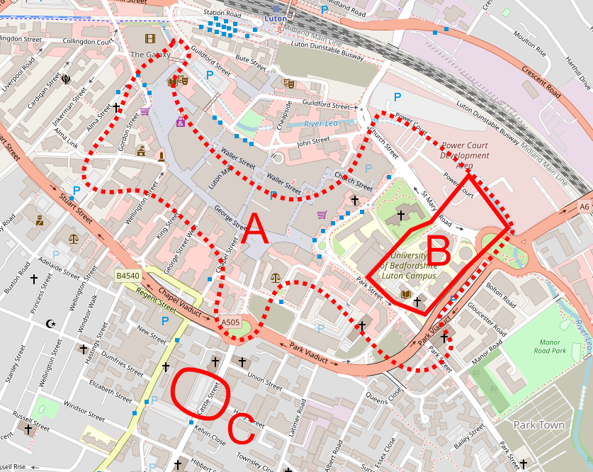
12th century castle
During the Anglo-Saxon period, the settlement of Luton was controlled by the kings of Wessex; after the Norman Conquest of 1066, Luton became a royal manor, held by the Crown. At the start of the civil war of the 1130s and 1140s, known as the Anarchy, King Stephen gave the manor to Robert de Waudari, a mercenary leader who fought for Stephen against the Empress Matilda.
In 1139, Robert built a castle in Luton to control the south-western approach to the town, on what became the Holly Lodge site. It was positioned 200 m outside the main town, on a ridge of high ground overlooking the road between London and Bedford. The castle was rectangular in shape, at least 115 m long, 90 m wide and covering around 1 hectare. It would have been built from earthworks and timber, probably with a low motte within the bailey. Excavations showed that the protective bailey ditch may have been at least 4.5 m wide and 2.3 deep.
The civil war ended in 1153 and under the terms of the peace agreement, unauthorised castles constructed during the war were to be destroyed. Robert’s castle appears to have been demolished and the manor reverted to the Crown, the land being used for pasture. Castle Road took its name from this fortification and some earthworks appear to have survived above ground until the 1940s but were destroyed by later urban developments. Archaeological investigations in 1963 and 2004-5 found considerable remains of the castle beneath the surface.
13th century castle
In 1216, at the end of the First Barons’ War between the royalist supporters of King John and the rebel barons, the manor of Luton was briefly assigned to William Marshall, and then to Fulk de Breauté, one of John’s key lieutenants. Now one of the most powerful men in the kingdom, Fulk constructed a new castle in Luton, on the eastern side of the town alongside the Church of St Mary’s – the castle would have resembled a well-fortified manor house, and it formed an important administrative centre for the manor of Luton. Indeed, there may already have been a manorial centre on the site, dating back to the Anglo-Saxon period.
Fulk’s castle was approximately 120 m by 220 m, enclosing around 2.5 hectares, surrounded by a large moat, up to 12 m wide and 3 m deep. Fulk damned the river between the vicarage and his castle, helping to retain water within the moat, despite the complaints from the Church that this had flooded their local land and crops. A large rectangular building, possibly a hall, was located in the south-west of the site, and various industrial buildings in the centre. There would also have been agricultural buildings, a chamber block and stables, as well as potentially a court house.
Soon afterwards, the young King Henry III’s Government ordered all royal castles to be surrendered to the Crown; by 1224 Falk had fallen out of royal favour, surrendered Luton Castle, and was in exile. The castle was probably then dismantled, although a courthouse remained in operation on the site until 1618, the remainder of the site being used for pasture.
The castle moat survived for several centuries, and in the late 18th century the Society of Friends established a graveyard on the north-west side. Luton manor was heavily subdivided between the late 13th and late 15th century, reducing any need for an administrative centre in Luton. By the end of the 19th century, the old castle site had been levelled and the moat filled in, being occupied by housing. Archaeological investigations between 2009-10 traced the main parts of the medieval earthworks.
Bibliography
- Albion Archaeology. (2009) Land at the University of Bedfordshire Park Square, Luton Archaeological Trial Trenching Project. Albion Archaeology: Bedford.
- Albion Archaeology .(2003) Extensive Urban Survey – Bedfordshire and Luton. Bedfordshire County Council and English Heritage: Bedford.
- Keir, Wesley and I. Turner. (2012) 4 Lea Road, Luton: Archaeological Excavation, Recording, Analysis and Publication. Albion Archaeology: Bedford.
- Keir, Wesley. (2017) “Archaeological investigations on the western edge of the site of Fulk de Breauté’s castle, Park Square, Luton,” Bedfordshire Archaeology, Vol. 27. pp.245-266.
- Woodley, Nuala C. and Joe Abrams. (2017) “Inside Fulk de Breaute’s 13th-century castle,” Bedfordshire Archaeology, Vol. 27. pp.267-282.
Attribution
The map in this article is based on OpenStreetMap open data, licensed under the Open Data Commons Open Database License (ODbL) by the OpenStreetMap Foundation (OSMF).