Lidgate Castle was a medieval fortification in the village of Lidgate, Suffolk, dating from the 12th century. The defences were extended around the settlement when it was redeveloped as a planned town in the 13th century, but the castle was abandoned within a few decades. Only earthworks and fragments of wall now survive.
History
Lidgate was an Anglo-Saxon settlement, lying between Clare and Exning in Suffolk, and may have been first occupied by the Romans. After the 1066 conquest, Rainald, or Reginald, the Breton was given the manor by William the Conqueror. Rainald retired to Jerusalem, leaving his lands to Bury St Edmunds’ Abbey. The abbey endowed it to their hereditary lay stewards, who by the mid-12th century, was Maurice de Windsor.
During the civil war known as the Anarchy between 1139 and 1154, Maurice probably fortified the manor by constructing Lidgate Castle. It probably took the form of a simple motte-and-bailey design, at the north end of the settlement. It would have formed part of a sequence of defences constructed in this period across the region, including at Lindsey, Milden and Offton. Maurice passed his lands to his nephew Ralph de Hastings and his descendants in 1155.
During the First Barons War of 1215-1216, William de Hastings joined the rebel barons. In April 1216, King John ordered Hervey Belet, the Constable of Norwich Castle, to raid William’s estates, destroy his castle and seize his lands. William made his peace with the King that August and appears to have regained ownership of the castle.
Henry de Hastyngs inherited Lidgate and redeveloped the settlement. The village was relaid as a small borough centred around a market place, protected with defensive ditches linked to the castle, and a lake at the bottom of the hill. Henry helped to lead the rebels in the Second Barons War of 1264-1267 and garrisoned the castle against the King, along with nearby Kirtling Castle in Cambridgeshire, as well as the castles at Scarborough and Winchester. Despite being captured and making his peace with the King, he returned to the conflict and finally surrendered in 1267, dying two years later.
Henry’s son, John, was initially a minor, but inherited lands across Wales and England from his uncle, and probably took far less interest in Lidgate than his predecessors. Lidgate Castle was abandoned soon after the Second Barons War and in the years after the Black Death the settlement faltered, remaining a small village into the 21st century. It is protected under UK law as a Scheduled Monument, and after archaeological surveys by the Lidgate Archaeology Group in 2018, this protection was extended across the remains of the planned town.
Architecture
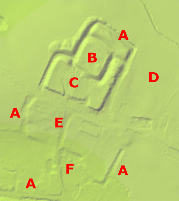
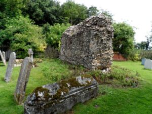
Only earthworks remain of Lidgate Castle today. The surviving motte is approximately 48 m by 48 m (157 ft by 157 ft) across and 2 m (6.5 ft) high, protected by a 5 m (16.5 ft) deep, 20 m (65.5 ft) wide ditch, and a 3.2 m (10.5 ft) high bank. The south-east corner of the motte has a low, circular mound, approximately 10 m (33 ft) across, which may have supported a tower. The motte was entered across a causeway to the south, which originally would have held a gate. Some fragments of flint walling survive, which may have formed part of the defences.
The castle’s bailey contains St. Mary’s, a church that probably started as the castle chapel, before being expanded in the late 13th or early 14th centuries. Earthwork enclosures stretch around the boundaries of the planned town, although the north-east corner of these was destroyed after 1957.
Bibliography
- Martin, Edward and Clive Paine. (2015) “Excursions, 2015”, Suffolk Institute of Archaeology and History, Volume 43, Part 4, pp.653-680.
Attribution
The text of this page is licensed under CC BY-ND 4.0.
Photographs on this page are drawn from the Geograph andthe UK’s Department for Food and Rural Affairs websites, as of 5 December 2021, and attributed and licensed as follows: “Section of wall“, author Bikeboy, released under CC BY-SA; “Lidar map“, copyright the Environment Agency, released under Open Government License 3.0.