Reimagining Southampton
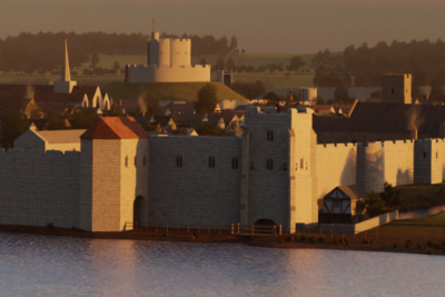
Southampton at dawn, 1500 AD. The sun slowly creeps up over the walls of the medieval city, catching the walls of the castle, and banishing the shadows from the street. Henry VII is the ruler of England and, after the violent years of the Wars of the Roses, the country is at piece. The threat of civil war or French attack remains real, however, and Southampton’s defences are still kept well maintained by the town’s citizens. The seagulls cry along Southampton’s quays, looking for left overs from the local fisherman; the bells of the Franciscan Friary sound out, encouraging the townsfolk to rise; and the earliest risers from Southampton’s great houses and poorer quarters are already on the streets, accompanied by the sounds of the pigs, cattle and chickens that share the town with them all.
For a full history of Southampton’s defences, see our articles on Southampton’s town walls, Southampton Castle and God’s House Tower.
Southampton in 1500 AD

At the start of the 16th century, Southampton was an important medieval trading town. Its various docks linked the south of England to the rest of Europe and the New World, and formed the source of the town’s wealth.
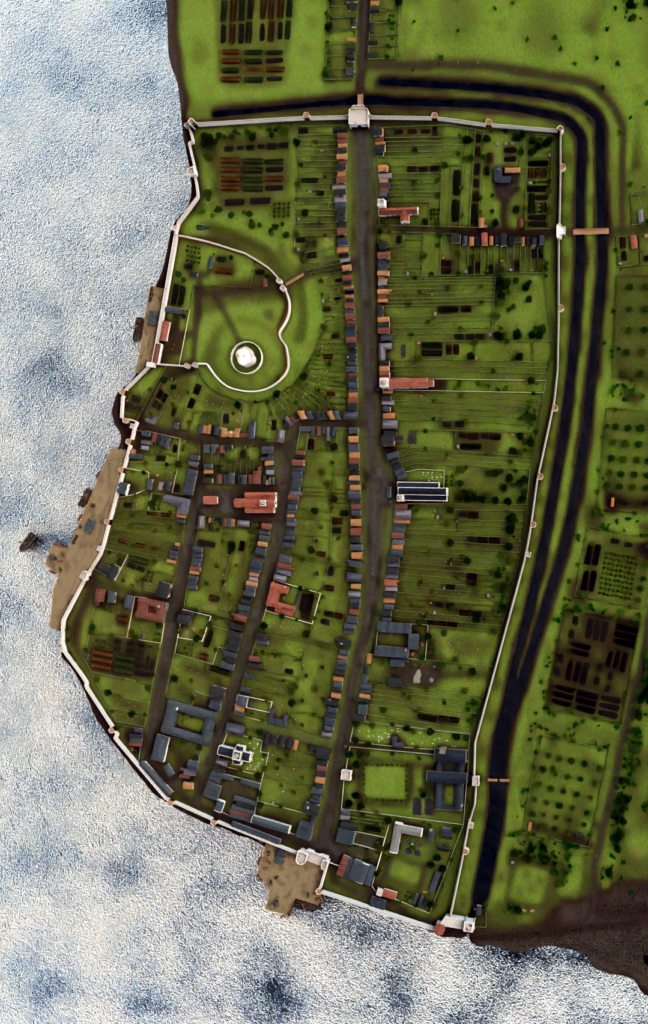
Two kilometres of stone walls encircled Southampton, constructed after a disastrous French raid on the town in 1338, with towers protecting both the landward side and facing out over Southampton Water. Eight gates gave access to the town. The walls remained important: only five years before, the French had attacked the Venetian trade ships in Southampton’s harbour.
By 1500, Southampton was a crowded town, and its population had begun to spill out beyond its walls along the approach roads, creating new suburbs. We know a lot about the citizens of Southampton at this time, as a result of the survival of a document called a “terrier” that recorded which landowners were responsible for maintaining particular stretches of the walls.

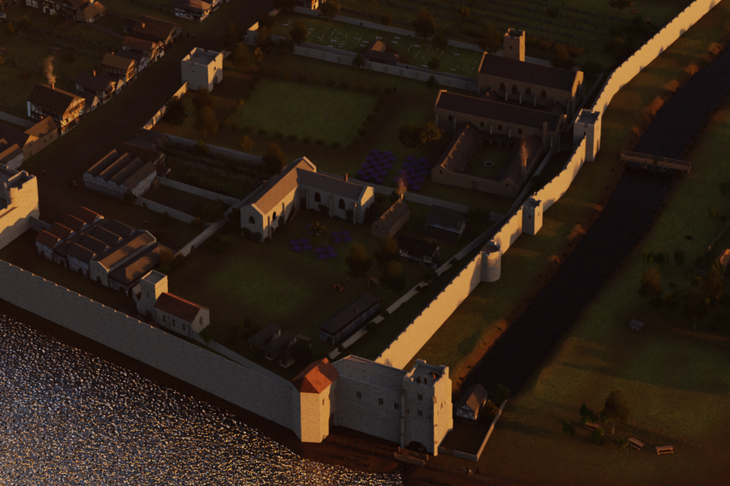
The south-east corner of the town overlooked the saltmarshes that stretched along the coastline, and the town’s bowling green. The Franciscan Friary dominated the district, with its own gatehouse and bridge crossing the city ditches. God’s House Hospital, which provided shelter for travellers following the “Old Way” pilgrimage route to Canterbury, occupied much of the rest of the south-east corner. The Chapel of St Julian served the local community.
The southern edge of the town was protected by God’s House Tower, a powerful artillery complex built in the early-15th century, and the fortified Watergate, which over-looked the southern docks. A mill stood just outside the walls beneath the tower, fed by the tides that flowed beneath it into the town’s ditches. The town’s bowling green was located just beyond the mill, along with orchards and fields owned by the hospital and friary.

Within the main town, English Street, now called High Street, ran across the length of the town, from Bargate in the north, to Watergate in the south. A few years later, the antiquarian John Leland described this as “one of the fairest streets that is in any town of all England”. It held three of Southampton’s churches, All Saints, St Lawrence’s and Holy Rood.
French Street and Bull Street – now called Bugle Street – ran parallel to English Street, but closer to the docks and Southampton’s trade. Together they housed the grand dwellings of some of Southampton’s richest burgesses, as well as the wealthy Italian merchants who resided in the town – such as Bull Hall and West Hall. They also held many of the civic institutions that managed trade, including the Wool and Tin Houses. Most of the merchants’ houses doubled as shops, with cellars beneath them designed to store their products at the ideal temperature. French Street and Bull Street met at St Michael’s Church – the most prestigious church in the town – adjacent to St Michael’s Square, where the Fish Market and Cloth Hall, which rested on a tall wooden platform, formed a commercial hub.
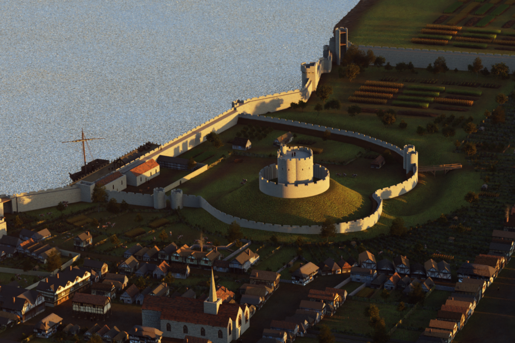
Southampton Castle dominated the north-west of the town, the stone keep on its 11th century motte and the outer bailey walls forming part of the protective circuit of the town. The royal castle had its own quay and was used to store wine and other luxury imports for the Crown.

Overlooked by the castle, the north-east corner held some of the poorest members of the community, clustered around the roads leading up to East Gate, which led out towards the earlier heart of Southampton and the older church of St Mary. Beyond the northern walls, lay the suburb of Above Bar, stretching through the fields and common land, towards the church of St Mary Magdelen, and the remains of the town’s lepers hospital.
Southampton drew its piped water from the northern hills, brought in through pipes that met conduit heads along English Street, terminating outside the friary, which had once controlled the water supplies.
Visiting the sites

Much of medieval Southampton still survives today. The western stretch of the town walls is intact, and retains many of the original medieval features. One of the merchant houses on French Street is preserved by the English Heritage organisation; the Tudor House and Garden can be visited on Bugle Street; and the Cloth Hall, originally on St Michael’s Square, was dismantled and rebuilt adjacent to West Gate, and is now open to visitors as the Tudor Merchant’s Hall. Several of the taverns seen in this 1500 reconstruction remain, albeit significantly altered over the centuries; the Duke of Wellington and the Red Lion pubs stand out as notable examples.
Technical details
For those interested in the technical details, the project was carried out using a software package called Blender. Blender is a free product, developed and maintained by a community of volunteers around the world, and can be downloaded here.
Bibliography
- Berger, L., J. W. Warner, H. R. G. Evenden, A. E. Carter and J. N. Calton. (1964) “Conversion of God’s House Tower, Southampton”, Official Architecture and Planning, Volume 27, Number 3, pp. 289-293.
- Brown, Richard and Alan Hardy. (2011) Trade and Prosperity, War and Poverty: An Archaeological and Historical Investigation into Southampton’s French Quarter. Oxford, UK: Oxford Archaeology.
- Burgess, L. A. (ed) (1976) The Southampton Terrier of 1454. London, UK: Her Majesty’s Stationery Office.
- Butler, Cheryl. (2020) Power, Prisoners and Paintings: The History of God’s House Tower. Southampton, UK: GHT.
- Creighton, Oliver Hamilton and Robert Higham. (2005) Medieval Town Walls: An Archaeology and Social History of Urban Defence. Stroud, UK: Tempus.
- Davies, J. Silvester (1883) A History of Southampton. Southampton, UK: Gilbert and Co.
- Jones, Matt. (2008) “Southampton in 1454: A Three-Dimensional Model of the Medieval Town,” 3DVisA Bulletin, Number 4.
- Pelham, R. A. (1963) The Old Mills of Southampton. London and Southampton, UK: Southampton Corporation.
- Turner, Hilary. (1971) Town Defences in England and Wales. London, UK: John Baker.
Attribution
The text of this page is licensed under CC BY-ND 4.0. The digital reconstructions include digital assets, attributed and licensed as follows: “Medieval Crane” by chuckcg, released under Creative Commons Attribution 4.0.
