Westgate Bridge – also known as the Great Bridge – was a fortified bridge on the west side of Gloucester, England. Built in the late-12th century, it was constructed in stone with a defensive gateway, and maintained by St Bartholomew’s Hospital. A larger gatehouse was added in the 16th century, and the bridge saw service in the English Civil War of the 1640s. In 1809, the bridge was pulled down and a sequence of newer bridges built on the site. No traces of the medieval bridge now survive above ground.
Background
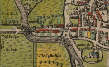
Westgate Bridge was constructed in the late-12th century, on the west side of the city of Gloucester. Gloucester was a growing, powerful civic centre, with a royal castle and docks accessible from the Bristol Channel. The western approach to Gloucester was different in the medieval period than today, as the rivers have shifted over the centuries. There was then three distinct branches of the River Severn, meandering through the meadowlands. On the far west was the Maismore branch, and closer to Gloucester were the middle and easterly channels.
The Romans had built a quay and a bridge over the most eastern branch of the river, later called the Old or Little Severn, which was then the largest part of the Severn river. By 1086, and the recording of Domesday Book, wooden bridges stretched across most of the key crossing points – the local administrative unit was called the Tolangebriges Hundred, and there was a “Gloucester Bridge” – probably referring to a bridge crossing the Old Severn – in existence in the early Norman period.
The most westerly branch of the river, the Maismore branch, came to be crossed by a 900 m (2,900 ft) causeway over the floodplains, and Over Bridge, which transited the river itself. By the 1540s, the causeway formed a series of stone arches enabling water to drain during the flood season. The medieval stone bridge was replaced in 1830 with a crossing designed by the engineer Thomas Telford. A stone bridge was built across the Old Severn probably in the late 11th or early 12th-century. Known as the Foreign Bridge, it was built in sandstone ashlar-faced rubble, with seven arches and was approximately 90 m (290 ft) across. The Old Severn river branch ultimately faded away and by the 19th century the Foreign Bridge was pulled down.
Construction
The middle part of the approach to Gloucester was occupied by Westgate Bridge. The first stone bridge here was probably built by Nicholas Walred, a chaplain, during the reign of Henry II (1154-1189), although there was probably an earlier timber structure on the site. St Bartholomew’s Hospital was established nearby, and for several centuries they acted as the wardens and preachers of the bridge, presumably also collecting donations from travellers.
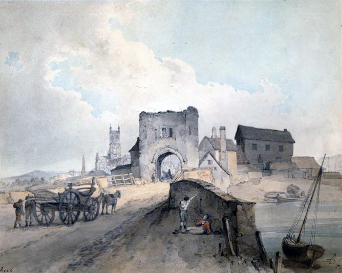
The bridge was substantial and probably originally had eight stone arches, built with a rubble core faced with limestone ashlar. There was a defensive gate, probably in stone, on the east end of the bridge, and a drawbridge. The bridge was apparently damaged in the Second Barons’ War, and in 1264 Henry III donated four oak trees to repair the bridge; funds were still being gathered by the hospital for this purpose in 1266.
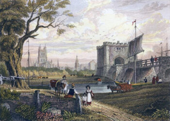
In the 16th century, Gloucester was growing once again on the back of pilgrimage to its cathedral and trade. In 1505, control of the bridge passed to the burgesses of Gloucester. They successfully argued that they had spent 300 marks (equivalent to £200)1It is difficult to accurately compare medieval financial figures with modern equivalents. See our article on medieval money for more details. rebuilding the bridge and, as a result, had the right to collect the tolls from travellers. It was popular for citizens to leave money in their wills for the maintenance of the bridge. By the 1560s, the hospital was also under the control of the town. As part of the redevelopment of the of the bridge, a new stone gatehouse with four turrets was constructed on the east end of the bridge, incorporating parts of the old gateway, under the custody of the royal sheriff.
During the English Civil War of the 1640s, Gloucester was held by Puritans sympathetic to Parliament, but came under Royalist siege in 1643. Two arches of Westgate Bridge were pulled down and replaced by a defensive drawbridge. Parts of this were repaired during the 18th century. Maintaining the bridge became an ongoing issue, however, with damage from flooding, ice in winter, and accidental damage from passing boats.
Reconstruction
In 1806, Parliament approved the levying of tolls for reconstruction of Westgate Bridge. The old medieval structure was pulled down in 1809, a temporary wooden bridge constructed alongside, and between 1813 and 1816 a new stone bridge with a single arch was erected by the architect Robert Smirke. The town went on to rebuild the Over Bridge and causeway as well, but the ongoing tolls was resented by many citizens. A riot broke out in 1827, resulting in the destruction of the Westgate tollhouse. After troops put down the disturbance, the town agreed to cease the tolls. The Westgate Bridge was rebuilt again in 1941 in steel, and reconstructed once more in the early 1970s.
Archaeological investigations between 1971 and 1973 uncovered the remains of the medieval Westgate Bridge, although these are not visible today.
Bibliography
- Hebert, N. M. (ed) (1988) A History of the County of Gloucester: Volume 4, the City of Gloucester. London, UK: Victoria County History.
- Hurst, Henry. (1974) “Excavations at Gloucester, 1971–1973: Second Interim Report,” in The Antiquaries Journal, Volume 54, Issue 1, pp.8-52.
- Moss, Philip and Andrew Armstrong. (2021) Gloucester: Recreating the Past. Cheltenham, UK: The History Press
Attribution
Images include those from the British Museum, the University of Cambridge and AncestryImages websites, and are attributed and licensed as follows: “Westgate Bridge, late 18th century“, photograph copyright Trustees of the British Museum, released under CC BY-NC-SA 4.0; adapted from “John Speed’s map of Gloucester“, photograph copyright University of Cambridge, released under CC-BY-NC 3.0; “Westgate Bridge, late 18th century“, AncestryImages.com.