Hay-on-Wye’s town walls were built around the town in Powys, Wales, in the early 13th century. Although still in good condition in the 16th century, by the early 19th they had been largely destroyed, and only traces remain today.
History
The Normans began to make incursions into South Wales from the late-1060s onwards, pushing westwards from their bases in recently occupied England. The Norman adventurer Bernard de Neufmarché conquered Brecknock in 1091 and assigned the manor of Hay to one of his followers, Philip Walwyn. The English lordship of Hay, known as Hay Anglicana, became a wealthy town and the lands passed by marriage to Miles of Gloucester and then into the de Braose family. In the late 11th or early 12th century, a new timber and earthwork castle was built in the town, which was expanded in 1200 using stone.
The region remained tense and subject to numerous conflicts. During the First Barons’ War, Reginald de Braose joined the alliance against King John; the King then successfully attacked Hay-on-Wye in 1215. During the reign of John’s son, Henry III, the Welsh prince Llewelyn the Great attacked and burnt the town and castle in 1231. The destruction encouraged the Crown to agree to the gathering of local taxes for three years to pay for the construction of town walls- a grant known as murage – which was renewed for a further three years in 1237.
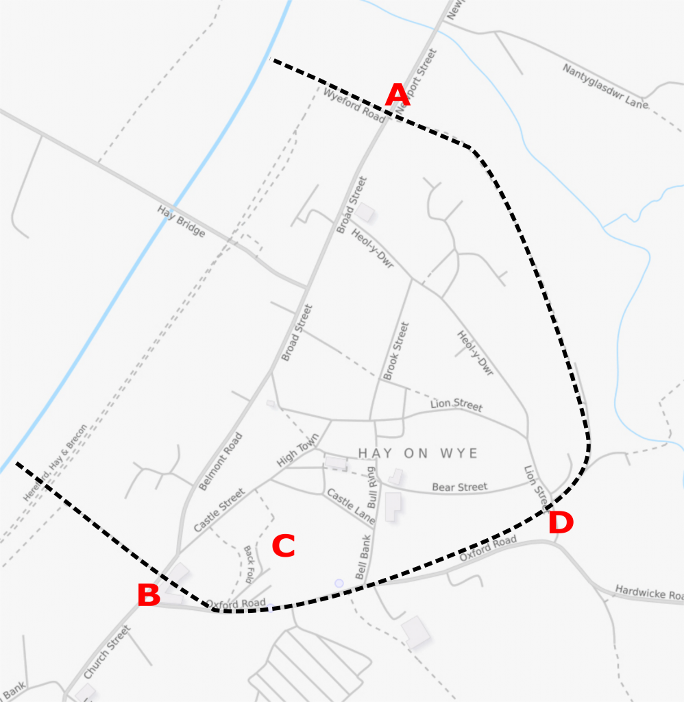
The resulting fortifications formed a triangle, running from the river in the south-west corner of the town, incorporating the castle along the southern edge, and running north back up to the river. The walled circuit had three gatehouses – Carlesgate in the southwest, Lion Gate in the south east, Nyport Gate (also known as the Water Gate) in the north – and a postern gate. As well as the houses of the settlement, the walls enclosed gardens and meadows.
During the Second Barons’ War, Prince Edward captured the town in 1263 but it was recaptured by Simon de Montfort and Llywelyn ap Gruffudd the following year. Hay-on-Wye was further damaged by the Welsh rebellion led by Owain Glyndŵr around 1401, and in 1460 during the Wars of the Roses. When the antiquarian John Leland visited between 1535 and 1543, he described the town walls as “right strong”, although the town within was by now “wonderfully decaied”.
By the early 19th century, the walls had largely been destroyed, although parts were incorporated into local buildings and garden walls. In the 21st century, only these fragments, parts of the foundations and earthworks survive; as a result, the exact location of the Lion Gate is unknown. These remains are protected under UK law as a Grade II listed building.
Bibliography
- Bond, C.J. (1987) “Anglo-Saxon and Medieval Defences,” in Schofield, J. and Leech, R. (eds) Urban Archaeology in Britain. London, UK: Council for British Archaeology. pp. 92-116.
- Creighton, O.H. and R. A. Higham. (2005) Medieval Town Walls: An Archaeology and Social History of Urban Defence. Stroud, UK: Tempus. ISBN 9780752414454.
- Toulmin-Smith, Lucy (ed). (1906) Leland’s Itinerary in Wales. London, UK: Bell and Sons.
Attribution
The text of this page is licensed under under CC BY-NC 2.0.
Photographs on this page include the plan of the Hay town walls, which is based on an underlying map copyright OpenStreetMap contributors, and released under CC BY-SA 2.0.