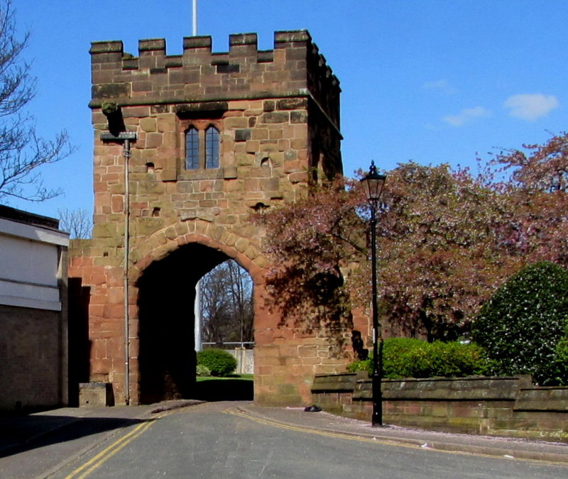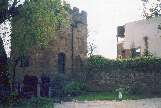
Coventry’s city walls were built around the Warwickshire city in the 14th century. The economic growth of the city, combined with the introduction of a new local government in the 1355, encouraged work to begin the following year. The walled circuit was almost finished by 1400, but the growing settlement meant that it was not fully complete until 1534. With twenty defensive towers and twelve gates, it was a symbol of the city’s political importance and pride.
After the English Civil War, Charles II ordered the walls to be pulled down in 1662, largely as a punishment for the city having supported the Parliamentary faction during the conflict. Most of the gates were demolished as the city grew still further in the 18th century, and now only Cook Street and Swanswell gates survive, along with small fragments of the originally 2.2 mile (3.5 km) long walls.
History
11th-16th centuries

After the Norman invasion of 1066, Coventry was a modest sized town, dominated by its two major landowners, the cathedral and the Earl of Chester. Although Coventry Castle was built around 1100, the city of Coventry was not walled until the 14th century.
The city grew in size and commercial importance and became one of the most important in England – some estimates place it as the fourth most powerful in the country, backed by the lucrative wool trade and its guilds and religious houses. As a result, by the beginning of the 13th century the city was surrounded by ditches and had movable “bars” controlling access to the main routes in and out the city.
Edward III gave permission for the city to begin to levy murage taxes to raise money for new defences in 1329. Construction began on the new city walls in 1356, with the mayor of Coventry, Richard Stoke, recorded as laying the first stone at New Gate. The revenue from the murage taxes were supplemented by King Richard II allowing stone to be quarried from his royal park at Cheylesmore.
The main construction effort was initially finished by around 1400, but a lot of further building and reworking was subsequently carried out to accommodate the expanding city, and the final walled circuit was not finally completed until 1534. As a result, the line of the walls was quite irregular, reflecting the growth of the city rather than simply military practicalities.
Completed, the walls measured nearly 2.2 miles (3.5 km) around and were built from red sandstone with a rubble core, over 8 feet (2.4 m) thick and 12 feet (3.7 m) high. The circuit was defended with twenty towers and twelve gates. The city gates were titled New Gate, Gosford Gate, Bastille Gate (later Mill Gate), Priory Gate (Swanswell Gate), Cook Street Gate, Bishop Gate, Well Street Gate, Hill Street Gate, Spon Gate, Greyfriars Gate, Cheylesmore Gate and Little Park Street Gate.

Watchmen for the walls and gates were provided by dividing Coventry into ten wards, each of which had the task of providing a number of men on a rotating basis. Later, some towers along the wall were let to private citizens, on the condition that they assisted in maintaining stretches of the defences.
With its new walls, Coventry was described as being the best-defended city in England outside London. The city of Coventry faced few military threats, however, and the decision to build the walls appears to have been driven by political and economic drivers – walls were important symbolically to a city’s leading citizens and in turn could bring additional trade. The decision to build the walls in the 1350s appears to be linked to the “Tripartite Indenture” of Coventry in 1355, which established a common local government for the city. This brought together the north of the city, belonging to Coventry Priory, with the south, belonging to the Earl of Coventry, with Richard Stoke becoming the first mayor of the new government at the end of that year.
17th-21st centuries
The walls were maintained into the 17th century and were repaired during the English Civil War of the 1640s, when Coventry sided with Parliament against the royalist forces of King Charles I. The city was used to guard Royalist prisoners during the conflict.
After the restoration of Charles II in 1660, the new government decided to crack down on the Coventry elite. In 1662, the King gave orders for the city walls to be pulled down, citing the “mutinous and turbulent” character of the city authorities. Charles was also heavily influenced by the pro-Parliamentary sympathies of the city during the recent conflict – the destruction was an act of political revenge. The work was carried out by the Earl of Northampton and took three weeks to complete.
During the 18th century, many of the remaining gatehouses were demolished as the city grew during the early Industrial Revolution. New Gate was pulled down in 1762, Bishop Gate and Gosford Gate in 1764 and 1765 respectively, Spon Gate folllowed in 1771, Greyfriars in 1781, and Mill Lane Gate finally followed in 1849.
In the 21st century only two of the medieval gates survive – Swanswell Gate and Cook Street Gate – and some small sections of walling along Upper Well Street, and between Cox Street and Gosford Street. The remaining wall circuit is protected as a Grade I Listed Building and a Scheduled Monument. Fresh parts of the wall were uncovered in 2017 during building work to erect a new student accommodation block.
Architecture
Swansell Gate dates from around 1395 and is made from sandstone, with remains of the city wall to the north. The gate itself was blocked up in the 19th century when the gatehouse was used as a private house. The doorway and windows are 16th century in origin, and the crenellations, 20th-century. Today, Swansell Gate is surrounded by a park called the Lady Herbert’s Garden. Cook Street Gate dates from the early 14th century, possibly having been rebuilt towards the end of the century. Again, it is built from sandstone, with 19th or early 20th century crenellations. Both are gates are decorated with gargoyles.
Bibliography
- Creighton, Oliver and Robert Higham. (2004) Medieval Town Walls; An Archaeology and Social History of Urban Defence. Tempus: Stroud, UK.
- Monkton, Linda and Richard K. Morris (eds) (2011) Coventry: Medieval Art, Architecture and Archaeology in the City and its Vicinity. Routledge: London, UK.
- Turner, Hilary T. (1970) Town Defences in England and Wales. John Baker: London, UK.
Attribution
The text of this page is licensed under under CC BY-NC 2.0.
Images on this page include those drawn from the Geograph and Cambridge University Library websites, and are attributed and licensed as follows: “Cook Street Gate“, author Jaggery, released under CC BY-SA 2.0; adapted from “John Speed’s map of Warwickshire“, photograph copyright Cambridge University Library, released under a Creative Commons Attribution-NonCommercial 3.0 Unported License (CC-BY-NC 3.0); “Swanswell gate“, author E. Gammie, released under CC BY-SA 2.0.
